
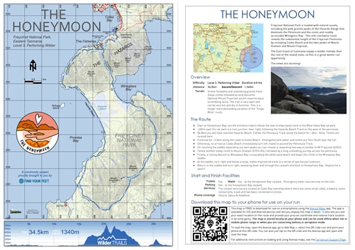
THE HONEYMOON
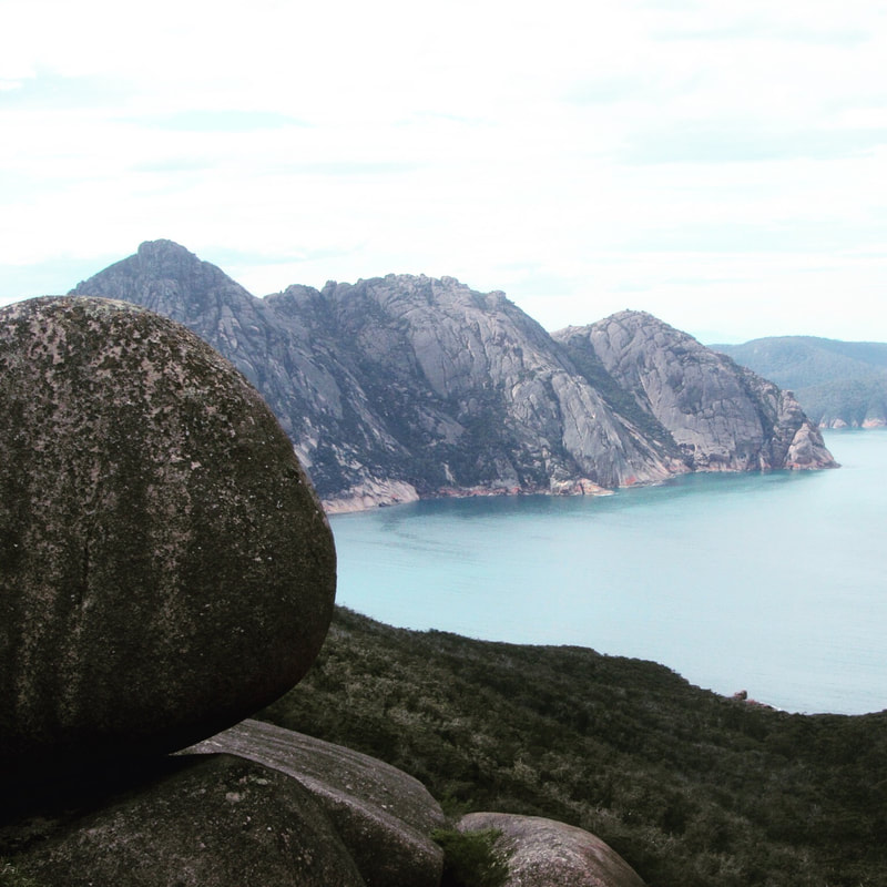
Freycinet National Park is home to dramatic pink granite peaks, secluded bays, white sandy beaches and abundant birdlife. Situated on Tasmania's beautiful east coast, the park occupies most of the Freycinet Peninsula and looks out to the Tasman Sea from the eastern side and back towards the Tasmanian coastline from the west.
|
Freycinet National Park is home to dramatic pink granite peaks, secluded bays, white sandy beaches and abundant birdlife. Situated on Tasmania's beautiful east coast, the park occupies most of the Freycinet Peninsula and looks out to the Tasman Sea from the eastern side and back towards the Tasmanian coastline from the west.
This route is inspired by an existing, well-known trail run hosted on the Freycinet Peninsula each year. However, our route begins at the majestic Honeymoon Bay and departs on the new shared-use track to the Wineglass Bay Carpark. From here you will pick up the Freycinet National Park's iconic trails, first following the rolling coastal trail to Hazard's Beach, all the while enjoying views back to 'mainland Tasmania'. After a shell-fossicking jaunt along the beach you will pick up the trail to Cook's Beach with its blue, blue waters that is idyllic for a swim! Now the big effort begins with a long, at times very steep climb to the Mt Freycinet/Mt Graham saddle, then to the top of Mt Graham itself. Then down, down, down, down to the world-famous Wineglass Bay campsite and beach for yet another refreshing dip. The route will take you along the soft sands of Wineglass Bay then up and over the lookout track where views back to Mt Graham and the beach await you. Afterwards, enjoy a flowing descent and many high-fives with other walkers to the Wineglass Bay carpark, before picking up the shared-use track back to Honeymoon Bay. The route concludes at Honeymoon Bay where another swim and relaxation period on the granite outcrops will reward you for your efforts. What a trail honeymoon! |
|
Overview
Difficulty Level 3, Performing Wilder Distance 34.5km Ascent 1340m Descent 1340m Terrain Combined coastal and mountainous terrain with steep climbs and uneven single trails. There is some beach running and short sections crossing granite outcrops too. Approx. Duration 4-6hrs Important Information: It is essential that you follow our route recommendations and enjoy this circuit in an anti-clockwise direction from the Wineglass Bay carpark, down the western side of the peninsula. This helps minimise the spread of Phytophthora (root rot). |
|
The Route
- Begin at Honeymoon Bay and follow the shared-use trail to the Wineglass Bay Carpark. There are toileting facilities and water located at both Honeymoon Bay and the Wineglass Bay Carpark.
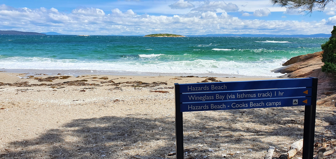
- Veer right after around 300m and follow the winding trail to Hazards Beach. Ensure you take in the views back to 'mainland Tasmania'.
- Traverse the length of Hazards Beach to the campground at its southern end. There is a stream here where water can be collected (not during dry seasons) and we recommend this is only used in emergencies and if it can be treated. There are toilets in the campground.
- From here, pickup the main trail south to Cooks Beach. This is an ideal place for a refreshing swim before turning left at the beach's beginning on the trail towards the summit of Mt Graham. If you need a toilet, you will need to traverse to the far end of Cooks Beach where the campground is located. There is water here which is suitable for drinking if treated.
- The track initially climbs steeply and then plateaus out, before climbing quickly again to the saddle of Mt Freycinet and Mt Graham. There is an option for an additional 45-minute side-trip to the summit of Mt Freycinet should you wish to. This is rocky and steep, and should only be attempted by those more experienced and accustomed to a long day out.
- After climbing to the summit of Mt Graham, descend to Wineglass Bay (toilet facilities located behind the beach) and then traverse the length of the beach to the northern end (there are further toilets located here too).
- Now you can rejoin the main day-hiking trail for a steady climb that includes many stairs to the Wineglass Bay Lookout. Make sure you stop to enjoy the view and reflect on just how far you have come. There are remarkable views bay to Wineglass Bay, Mt Graham and Mt Freycinet from here.
- Then it is down, down, down to the Wineglass Bay carpark to rejoin the shared-use track that will lead you back to Honeymoon Bay.
- Well done! You have concluded your huge circuit on the Freycinet Peninsula. Celebrate in honeymoon style with a swim in the bay then lounge on the granite outcrops... hopefully in the sunshine! Well done again!
Start and Finish Facilities
Toilets Yes - at the Honeymoon Bay carpark
Water Yes - at the Honeymoon Bay carpark but emergency water sources only on the trail
Parking Yes - at the Honeymoon Bay carpark
Services The closest services are located at the Freycinet Visitor Centre on entry to the National Park, or back in the township of Coles Bay where there are cafes, bakeries, small supermarkets and eateries.
Phone coverage Telstra, Optus and Vodafone reception.
|
Mapping & directions for this route
We have created 4 easy ways for you to choose from to safely and enjoyably navigate your way around this route. From a physical map to the more technology savvy, we have your safety at heart!
|
Here is a sample of the mapping and directions available as a PDF download or printed waterproof versions
|

FREE TO DOWNLOAD
|
Digitally interactive map for use on your smartphone (FREE)
This map is available for use on a smartphone using the Avenza Maps app. It runs on Android or iOS (iPhones & iPads) and lets you display the route map in detail and see exactly where you are on it. This will be invaluable in an emergency or if you are just unsure of your location on the course. You don’t need to be within mobile phone range to use the map as it’s stored locally. To load the map, open the Avenza app, go to Add Map, select the QR code icon and point your phone at the QR code here. To get the Avenza map app for your phone, see www.avenzamaps.com or just search for Avenza on the App Store or Google Play. For instructions on loading and using Avenza maps, see www.terrainium.com.au/UsingAvenzaMaps |
Concluded the route? Don't forget to get your completion badge or lapel pin!
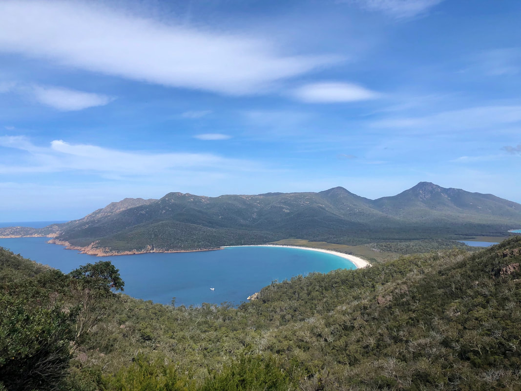
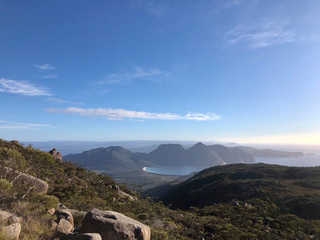
The view to Wineglass Bay from the Wineglass Bay Lookout. Mt Graham and Mt Freycinet are the peaks in the background.

|
Highlights
|
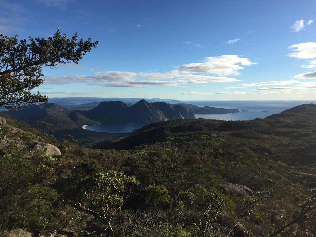
Views of Wineglass Bay and The Hazards await you from the long climb to the summit of Mt Graham!
About the Freycinet National Park
With thanks to the Tasmanian National Parks & Wildlife Service for access to the following information...
Overview
Freycinet was reserved as a national park in 1916, making it the oldest national park in Tasmania, alongside Mount Field National Park. With thanks to Tasmanian Parks & Wildlife Service & Wineglass Bay for access to the following information...
Cultural heritage
The Freycinet National Park is located within the territory of the Oyster Bay nation which consisted of an estimated 600-700 people, and whose territory extended from the Derwent Estuary up the east coast to the Fingal Valley and westward to the Midlands. In 1816, Captain James Kelly recorded a party of Aboriginal people on Schouten Island. The historic records suggest that the Freycinet Peninsula and Schouten Island were part of the area of the toorerno-maire-mener clan within the Oyster Bay nation.
Today, significant Aboriginal sites are found along the coastlines, dunes and estuaries. This heritage includes shell middens, rock quarries, rock shelters, stone artefacts and other significant sites. The camping ground at Richardsons Beach is located adjacent to one of the most extensive shell middens known on the east coast, a highly significant cultural resource. These sites have a strong and continuing connection to the Tasmanian Aboriginal community. Please tread as gently & respectfully as you can.
Today, significant Aboriginal sites are found along the coastlines, dunes and estuaries. This heritage includes shell middens, rock quarries, rock shelters, stone artefacts and other significant sites. The camping ground at Richardsons Beach is located adjacent to one of the most extensive shell middens known on the east coast, a highly significant cultural resource. These sites have a strong and continuing connection to the Tasmanian Aboriginal community. Please tread as gently & respectfully as you can.
European Culture
Since the early years of European settlement, whaling parties, tin and coal miners, and pastoralists are among those who have lived and worked on the Freycinet Peninsula. Old mine shafts, abandoned farmers' huts and the remains of whalers' camps today form part of the rich cultural heritage of the park.
Whaling parties, tin and coal miners and pastoralists were among those who lived and worked on the Freycinet Peninsula since the early years of European settlement. Old mine shafts, abandoned farmers’ huts and the remains of whalers’ camps today form part of the rich cultural heritage of the park.The majestic beauty of Freycinet’s granite mountains and white, sandy beaches have also long been admired by naturalists, artists and writers.
On navigating the east coast of Tasmania in 1642, Abel Tasman named Schouten Island after a member of the Council of the Dutch East India Company. The adjacent peninsula was initially thought to consist of a chain of islands, but this myth was dispelled during the visit of Nicholas Baudin, the French explorer, in 1802-03. The brothers Freycinet were senior officers on Baudin’s expedition, although it is unclear which one the peninsula was named after.
On navigating the east coast of Tasmania in 1642, Abel Tasman named Schouten Island after a member of the Council of the Dutch East India Company. The adjacent peninsula was initially thought to consist of a chain of islands, but this myth was dispelled during the visit of Nicholas Baudin, the French explorer, in 1802-03. The brothers Freycinet were senior officers on Baudin’s expedition, although it is unclear which one the peninsula was named after.
High granitic mountains whose summits are almost completely barren, form the whole eastern coast of this part of Van Diemen’s Land. They rise sheer from the base. The country which adjoins them is extremely low and cannot be seen unless viewed from only a little distance at sea. It is to this strange formation that we must doubtless attribute the errors of the navigators who had preceded us into these waters and who had mistaken these high mountains for as many separate islands.
Flora & Fauna
There is an abundance of wildlife on the Freycinet Peninsula ranging from wombats, wallabies and quolls to sea eagles, black swans, whales and dolphins.
The Freycinet Peninsula is one of the State's most scenic coastal areas. The waters off the Freycinet Peninsula are regularly visited by whales, particularly southern right whales, during the winter months. Mammals such as Bennett's wallabies, pademelons, and echidnas are commonly seen on land, while seals may be spotted resting on rocks.
Freycinet is also a great place to see birds, ranging from small nectar-feeding birds to spectacularly large birds. From Wineglass Bay and Cape Tourville lookouts you may be lucky enough to see white-bellied sea-eagles gliding overhead or Australasian gannets diving for food in the ocean. Wildflowers are also common at most times of the year.
Freycinet is also a great place to see birds, ranging from small nectar-feeding birds to spectacularly large birds. From Wineglass Bay and Cape Tourville lookouts you may be lucky enough to see white-bellied sea-eagles gliding overhead or Australasian gannets diving for food in the ocean. Wildflowers are also common at most times of the year.
We ask you to tread gently, remembering that we are visitor's to their habitats.
Geodiversity
The Freycinet Peninsula has formed over 400 million years and is effectively two eroded blocks of granite – the Hazards and the peninsula of Mount Graham and Mount Freycinet – connected by the sand isthmus that forms Wineglass Bay. The reason why the beaches are so white at Freycinet is thanks to the high levels of white quartz in the granite. This is a very hard type of rock which takes longest to erode, thereby washing up on the beaches to create long stretches of perfect sand. In fact, the sand is so pure that silicon mining at the Friendly Beaches in the Park's north was proposed. The granite also contains pink feldspar which causes the hazards to glow a reddish pink colour at sunrise and sunset.
Help Freycinet & its surrounds!
There are some active volunteer groups who help to preserve & protect the Freycinet Peninsula. We strongly encourage you to get involved!