
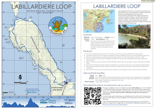
LABILLARDIERE LOOP
I stood there at the tip of the Labillardiere Peninsula, looking south and sucking in deep lungfuls of sea-soaked air. Suddenly it hit me, this has to be some of the freshest air on the planet with only Antarctica out there, somewhere. I felt wild! - Hanny Allston
|
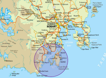
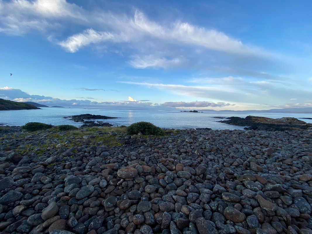
The Labillardiere Peninsula is situated in the South Bruny National Park. The route completes a clockwise loop of the peninsula providing magnificent views of the D'Entrecasteaux Channel and the rugged mountains of Tasmania’s Southern Ranges. There are deserted rock beaches to explore as southern swells crash onto the western coastline. Return along a beautiful, twisting single track through grassland and Eucalyptus forest along the eastern side of the peninsula.
|
|
Overview
Difficulty Level 1, Growing Wilder Duration 2.5-4hrs Distance 17.8km Ascent/Descent 585m Terrain Varying from smooth, sandy footpaths and fire trails to forested single tracks which can be slightly overgrown in some places. Some short climbs, stretches of beach, and sections of trail where visibility is limited by ferns and vegetation. |
|
Overview
Difficulty Level 1, Growing Wilder
Duration 2.5-4hrs
Distance 17.8km Ascent/Descent 585m
Terrain Varying from smooth, sandy footpaths and fire trails to forested single tracks which can be slightly overgrown in some places. Some short climbs, stretches of beach, and sections of trail where visibility is limited by ferns and vegetation.
The Route
Start and Finish Facilities
Toilets Yes.
Water Yes.
Parking Yes. There is extensive parking although be aware that this region is also a campground and can get busy.
Services None. The closest services are located at Alonnah which is an approximate 25km drive from Jetty Beach. This includes a medical centre and small corner store.
Phone coverage Telstra, Optus & Vodafone
Difficulty Level 1, Growing Wilder
Duration 2.5-4hrs
Distance 17.8km Ascent/Descent 585m
Terrain Varying from smooth, sandy footpaths and fire trails to forested single tracks which can be slightly overgrown in some places. Some short climbs, stretches of beach, and sections of trail where visibility is limited by ferns and vegetation.
The Route
- The start of the walking track is about 1¼ hours drive from the ferry terminal at Roberts Point, Bruny Island.
- Just before Cape Bruny, look for signage to Labillardiere Peninsula Walking Track. Start at the Jetty Beach Campground.
- Take the narrower walking trail uphill and away from the campsite. Turn right at the wide fire trail after ~ 900m.
- Follow Labillardiere Peninsula Circuit Walking Track NW to the very tip of the Labillardiere Peninsula, passing many beautiful coves.
- After a rocky beach you will climb up to the top of Mt Bleak (142m) where you will begin to capture views down to Patridge Island.
- Descend from Mt Bleak and follow a beautiful sandy beach to its end then up and over a small headland to Botlers Beach.
- From the eastern end of this beach look for the start of the single track that will follow the coastline all the way back to Jetty Beach.
- This final section of the route is often teaming with birdlife such as sea eagles, bronze-cuckoos and black cockatoos.
Start and Finish Facilities
Toilets Yes.
Water Yes.
Parking Yes. There is extensive parking although be aware that this region is also a campground and can get busy.
Services None. The closest services are located at Alonnah which is an approximate 25km drive from Jetty Beach. This includes a medical centre and small corner store.
Phone coverage Telstra, Optus & Vodafone
|
Mapping & directions for this route
We have created 4 easy ways for you to choose from to safely and enjoyably navigate your way around this route. From a physical map to the more technology savvy, we have your safety at heart!
|
Here is a sample of the mapping and directions available as a PDF download or printed waterproof versions
|

FREE TO DOWNLOAD
|
Digitally interactive map for use on your smartphone (FREE)
This map is available for use on a smartphone using the Avenza Maps app. It runs on Android or iOS (iPhones & iPads) and lets you display the route map in detail and see exactly where you are on it. This will be invaluable in an emergency or if you are just unsure of your location on the course. You don’t need to be within mobile phone range to use the map as it’s stored locally. To load the map, open the Avenza app, go to Add Map, select the QR code icon and point your phone at the QR code here. To get the Avenza map app for your phone, see www.avenzamaps.com or just search for Avenza on the App Store or Google Play. For instructions on loading and using Avenza maps, see www.terrainium.com.au/UsingAvenzaMaps |
Concluded the route? Don't forget to get your completion badge or lapel pin!
The Labillardiere Peninsula is situated in the South Bruny National Park and is one of the southern-most regions of the island. This route starts at the Jetty beach campground and completes a clockwise loop of the peninsula. Starting out on an old fire trail, you will progress down the western side of the peninsula which provides magnificent views of the D'Entrecasteaux Channel and the rugged mountains of Tasmania’s Southern Ranges. Here there are also deserted rock spree beaches to explore whilst southern swells crash onto the coastline. Continuing on, a steep but short climb up Mount Bleak to the highest point of the route is reached. From here you get your first views of Partridge Island, home to the rare and threatened Forty-Spotted Pardalote. This highpoint marks halfway of this route. At the tip of the peninsula you reach Butlers Beach where you will be rewarded with a close proximity to Partridge Island. From here you will then follow a beautiful, twisting single track through grassland and Eucalyptus forest along the eastern side of the peninsula back to Jetty Beach. This section of the trail is often teaming with birdlife such as sea eagles, bronze-cuckoos and black cockatoos.
|
|
Route Highlights
|
|
NB. whilst these trails are relatively easy to follow, this route is comprised of a number of shorter walking trails. We strongly recommend using our GPX download on a GPS device for accurate route guidance.
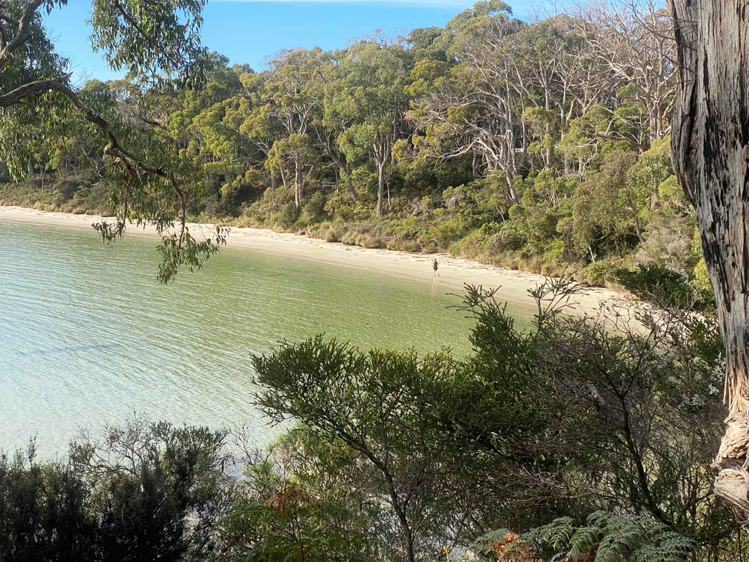
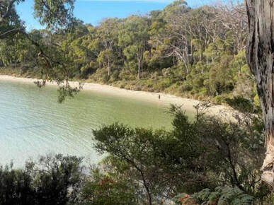
Your time on the trail will conclude at the stunning Jetty Beach!
|
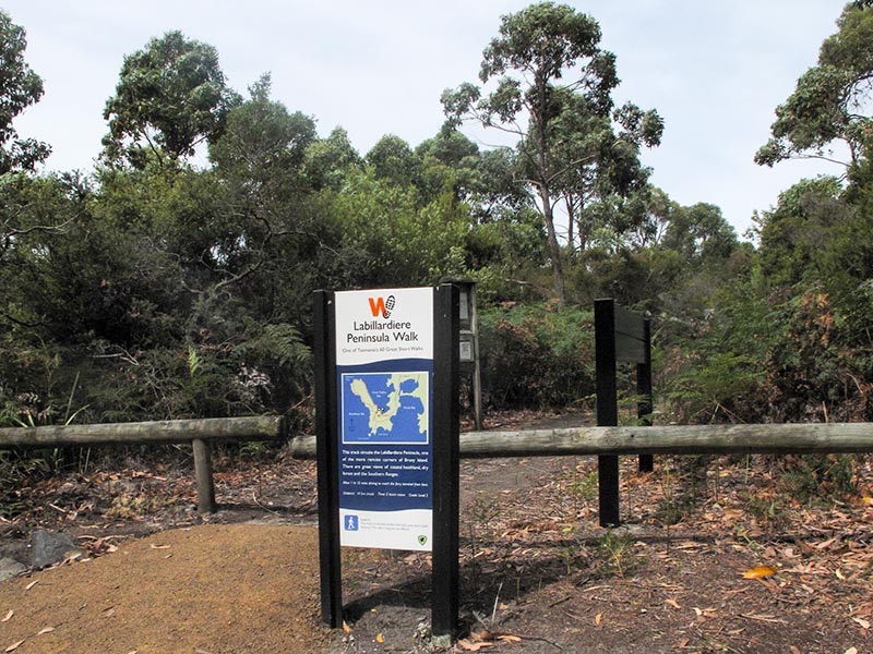
The start of the Labillardiere Peninsula walking track is in the corner of the campground, near the water tank.
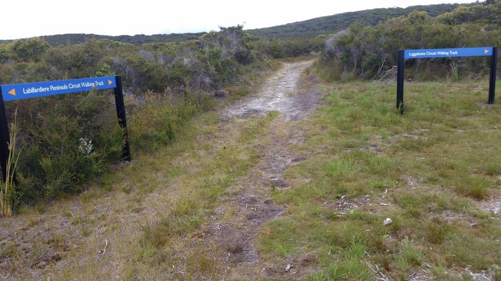
This junction occurs approximately 3.2km into the route. Continue straight ahead on the Labillardiere Peninsula Circuit Walking Track.
Before climbing Mt Bleak you get a fabulous view into the channel.
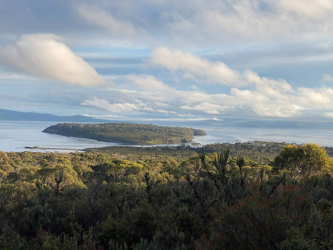
Descending Mt Bleak gives you wonderful views to Partridge Island
|
About Labilladiere & the South Bruny National Park
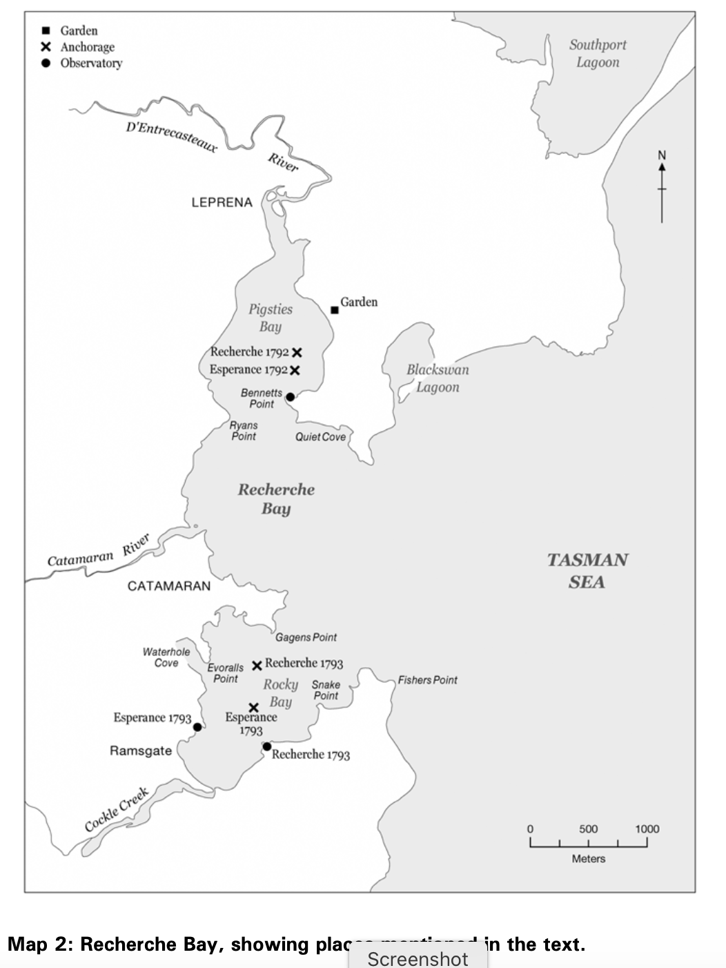
Image from 'The axe had never sounded' by John Mulvaney
|
We were filled with admiration at the sight of these ancient forests, in which the axe had never sounded - Labillardière 1792 Who was Labillardiere?With thanks to The Public Domain Review for access to this information:
Born in 1755 in Alençon in Normandy, France, Labillardière was the son of a lace merchant. After studies in botany and medicine, he visited England in 1783 and met Sir Joseph Banks. On his return to France, Labilllardière travelled in the Alps and later Cyprus, Lebanon and Syria—travels which provided the foundations for his important early work on the botany. He was selected to join Admiral Antoine Raymond Joseph Bruny d'Entrecasteaux's southern expedition in 1791. Labillardière was a supporter of the French Revolution and was known for his difficult temperament, something which caused him troubles at times. In an age when the discovery of new species and genera was often seen as the antipodes of botanical pursuit, Labillardière was accorded ample recognition. Even today, some fifty of the plant genera he established survive. However, in his papers and scientific works, Labillardière ventured beyond a mere cataloguing of nature. He had a strong interest in applied botany and his writings contain numerous observations on subjects such as timber, plant fibres, food crops and herbal pharmacology. They also include studies of significant aspects of animal behaviour and physiology, as well as the customs and social structures of indigenous communities he encountered in Australia and the Pacific. In the wake of Napoleon’s victories in Italy, Labillardière was appointed a special commissioner by the French government and to his discredit was involved in the plunder of Italian museums and libraries for France. In 1799 he married Marthe Goudes Desfriches, the twice-widowed daughter of a military surgeon, but they had no surviving children. He was elected a member of the Institut de France in 1800. Labillardière died in Paris on 9 January 1834 and is buried in Père Lachaise Cemetery. |
Aboriginal heritage
D’Entrecasteaux, according to the French King’s orders, was:
... to recommend to every person among the crews, to live in a good understanding with the natives, to endeavour to conciliate their friendship by a proper way of acting and respect; and must forbid them ... ever to employ force ... On every occasion ... act with great mildness and humanity ... His Majesty will look upon it as one of the most successful parts of the expedition that it may be terminated without costing the life of a single man.
That events in Paris would cost the king his own life, is one of the ironies of these instructions.
- 'The axe has never sounded', place, people and heritage of Recherche Bay, Tasmania; Mulvaney, D. J. (Derek John), 1925-
To their vexation of our early explorers, the Tasmanian indiginous inhabitants remained unseen. For D'Entrecasteaux, during most of their 1792 sojourn the barely sighted an aboriginal, although when they did they were quoted as saying, ‘The encounters we had with them later demonstrated that they are kind, without mistrust.’ Wherever expeditioners moved they saw ample proof of occupancy, including hearths, discarded utensils and artefacts, brush shelters, shell refuse, distant smoke and many tracks, which they followed to negotiate thick woodland. Yet the people remained concealed. This was a behavioural practice common to this region. When Tobias Furneaux anchored in Adventure Bay for five days during 1773, not a single inhabitant appeared. James Cook was there for two days in 1777 before people arrived, while Bligh waited vainly for 11 days in 1788, failing to meet anybody at close quarters before he sailed onwards.
The records of the d’Entrecasteaux and Baudin expeditions provide much vital data concerning Tasmanian traditional life at the time of contact. We now know that Bruny Island was home to the Nuenonne band. Related groups of families constituted a band, numbering up to 70 or 80 persons. Marriage took place between the Nuenonne band on Bruny and the Lyluequonny of Recherche Bay. Together with perhaps five other D’Entrecasteaux Channel bands north to the Derwent estuary, these people were the most maritime adapted Tasmanians. In recent times they are known as the Palawa. They crossed the waters between the islands and the mainland in craft made of eucalyptus bark lashed together in rolls.
There is a wonderful book written by Derek John Mulvaney called 'The axe has never sounded', place, people and heritage of Recherche Bay, Tasmania. It is free to download and a fascinating insight into this area. We highlighy recommend reading if you can.
European Culture
Recherche Bay is at the southern tip of Tasmania and is a place of amazing natural beauty combined with a rich, exciting human history. From the early aboriginal inhabitants to the European explorers, then laster the British colonisations, whaling stations, sawmills, coal mines, pubs and piracy... the landscape has seen it all! Yet, today, the naturalness of its setting remains remarkable unchanged.
In 1792, French Vice-Admiral Bruny d’Entrecasteaux brought his two ships Recherche and Espérance to anchor in the bay. ‘It will be difficult to describe my feelings at the sight of the solitary harbour situated at the extremes of the world, so perfectly enclosed that one feels separated from the rest of the universe,’ he wrote.
After their storm-tossed journey to this southern land, the ships and the 219 seamen, officers and scientists aboard recovered from scurvy and distemper at Recherche Bay. It provided fish, greens, fresh water, timber for repairs and an intriguing natural environment to study. A year later, after circumnavigating Australia, the d’Entrecasteaux expedition returned to Recherche Bay and this time met up with local Aboriginal people. The French diaries record the unfolding, friendly investigation of each other by these totally different peoples from opposite ends of the globe.
By 2003, many local Tasmanians believed that Recherche Bay needed rescuing. In a race against time and government indifference, many locals banded together to raise the alarm. Soon there were protest rallies in Hobart and a rising chorus of national and international concern.
With support from many individuals, including Emeritus Professor John Mulvaney, Founding Professor of Prehistory at The Australian National University, and a world-renowned authority on Indigenous and cultural heritage, philanthropists Dick and Pip Smith were able to privately purchase the peninsula. That guaranteed the forest’s survival as a centrepiece of the Recherche Bay region of which Labillardiere is a central feature too. It is hoped one day to include Recherche Bay into the Tasmanian Wilderness World Heritage Area.
Flora & Fauna
The national park contains several rare, endemic orchid species...
The plant communities in the South Bruny National Park are of high conservation value due to the occurrence of geographically significant species endemic to the island and not protected by reserves or parks elsewhere in Tasmania. On the Peninsula there are thriving dry sclerophyll communities such as eucalypt woodland, as well as heathland and coastal communities. The national park contains several rare, endemic orchid species including the endangered chestnut leek orchid (Prasophyllum castaneum) and the pretty leek orchid (Prasophyllum pulchellum), both of which are of high ecological significance due to their rare occurrence. These species generally occur in heathland communities.
Eucalyptus forests within the national park play an important role in creating habitat for many species of insects, birds and mammals. Common species are brown-top stringy bark (Eucalyptus oblique) with pockets of white gum (Eucalyptus viminalis), blue gum (Eucalyptus globules ) and white peppermint (Eucalyptus pulchella). The eyebright (Euphrasia fragosa) is another species of particular note; the park is one of the few places the plant occurs with only three other known populations, and is the only place where it is protected in a national park or reserve. The eyebright is a small flowering perennial occurring in open woodland and is highly vulnerable to disturbance where it exists on vehicle tracks and grazing areas.
Eucalyptus forests within the national park play an important role in creating habitat for many species of insects, birds and mammals. Common species are brown-top stringy bark (Eucalyptus oblique) with pockets of white gum (Eucalyptus viminalis), blue gum (Eucalyptus globules ) and white peppermint (Eucalyptus pulchella). The eyebright (Euphrasia fragosa) is another species of particular note; the park is one of the few places the plant occurs with only three other known populations, and is the only place where it is protected in a national park or reserve. The eyebright is a small flowering perennial occurring in open woodland and is highly vulnerable to disturbance where it exists on vehicle tracks and grazing areas.
We ask you to tread gently, remembering that we are visitor's to their habitats.
How can we help Bruny Island?
If you know an active volunteer program working in the South Bruny Island National Park then we would love to hear from you!