POLE DANCER
|
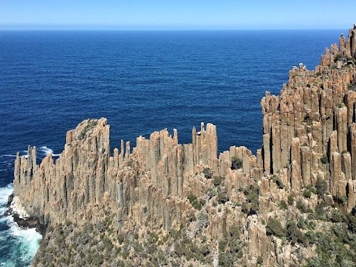
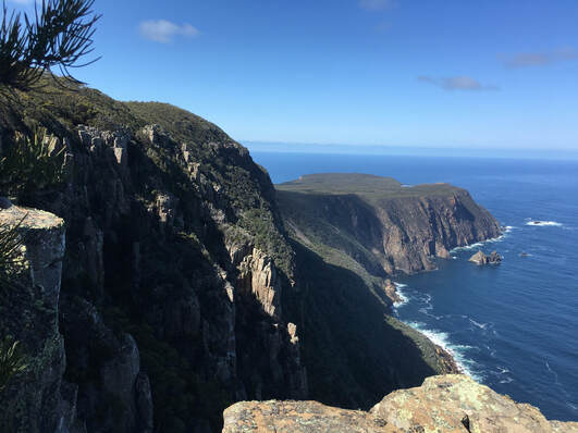
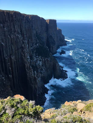
With some of the tallest sea cliffs in Australia, Cape Raoul is a daunting promontory jutting south from the Tasman Peninsula. This walk takes you through heath, woodland, and rainforest vegetation to stunning coastal seascapes that feature rock platforms, towering cliffs, offshore islands and swirling seas.
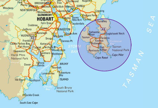
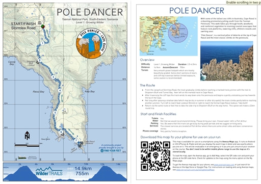
The Tasman Peninsula has an absolute abundance of dolerite and is a revered region for rock climbing amongst vertical terrain enthusiasts. Perhaps one of the most classic climbs on the peninsula is called 'Pole Dancer', a vertical pillar of dolerite at the tip of Cape Raoul. The route begins in the Cape Raoul carpark at the end of Stormlea Road and follows a very smooth, well graded track to the end of Cape Raoul. At 14.5km in length, this out-and-back route is littered with remarkable viewpoints, jaw dropping plunges to the turbulent seas below, and nooks out of the wind to simply be still, quiet and joy-filled. |
Start and Finish Facilities
Toilets Yes.
Water Not that we would recommend drinking. Please bring your own. Closest water refill is Port Arthur.
Parking Yes. There is extensive parking although be aware that this track can get busy during peak periods and we suggest arriving early.
Services The closest services are located at Port Arthur where there are some small cafes and basic convenience stores.
Phone coverage Very patchy Telstra reception.
The Route
- Begin at end of Stormlea Road, an approximately 1hr40min drive from Hobart. For full access instructions visit HERE. There are toilet facilities and a boot wash station at the start of the track.
- The track gradually climbs before reaching a marked track junction with the trail to Shipstern Bluff & Tunnel Bay. Veer left on the marked track to Cape Raoul.
- You will reach a formal viewing platform at your first encounter with the sea cliffs. These are some of the largest sea cliffs in Australia and provide spectacular views to Shipstern Bluff and into the distance to Bruny Island as well as the Hobart region. Please supervise children around these hazardous cliffs and unprotected track edges.
- After traversing the cliff tops the track winds its way down onto the peninsula and begins a gently undulating journey towards the tip of the Cape. It is on this passage that you will find some short sections of stairs. Please continue to supervise children around these hazardous cliffs and unprotected track edges.
- Not long after passing a shallow lake (which may be dry in summer or after dry spells) the track climbs gently before reaching another junction. Turn left to reach Seal Lookout (5mins) or right to reach the formal Cape Raoul lookout. Well done, you made it! Here you will be able to marvel at the spectacular coastline, including Cape Pillar & Tasman Island to the north.
- Return via the same route and feel free to take the side-trip to Shipstern Bluff on the way home. Please note that this will make the route closer to 22km if you do opt for these additional kilometers!
- Please note, after leaving the carpark there are no other toileting facilties on the track. It is recommended that you carry a trowel. Please bury all faecal waste and toilet paper / tissues in holes 15-20cm deep and at least 100m from water and tracks. Cover and disguise the hole when finished.
|
Mapping & directions for this route
We have created 4 easy ways for you to choose from to safely and enjoyably navigate your way around this route. From a physical map to the more technology savvy, we have your safety at heart!
|
|
FREE TO DOWNLOAD
|
Digitally interactive map for use on your smartphone (FREE)
This map is available for use on a smartphone using the Avenza Maps app. It runs on Android or iOS (iPhones & iPads) and lets you display the route map in detail and see exactly where you are on it. This will be invaluable in an emergency or if you are just unsure of your location on the course. You don’t need to be within mobile phone range to use the map as it’s stored locally. To load the map, open the Avenza app, go to Add Map, select the QR code icon and point your phone at the QR code here. To get the Avenza map app for your phone, see www.avenzamaps.com or just search for Avenza on the App Store or Google Play. For instructions on loading and using Avenza maps, see www.terrainium.com.au/UsingAvenzaMaps |
Concluded the route? Don't forget to get your completion badge or lapel pin!
Route Highlights
|
With thanks to Josh Miller and Chris Price for the production of this inspiring overview of our Pole Dancer route!
About Cape Raoul & the Tasman Peninsula National Park
With thanks to the Tasmanian National Parks & Wildlife Service for access to the following information...
Overview
In the State’s far south-east, linked to the rest of Tasmania by a small bridge over the Dunnally canal, lie the Tasman and Forestier peninsulas. They are protected by the Tasman National Park. Undoubtedly, the park’s greatest heroes are its sea cliffs – Australia’s highest. Towering dolerite spires rise from the Tasman Sea, culminating in capes Hauy, Pillar, and Raoul.
Aboriginal heritage
The Tasman Peninsula is within the homelands of the Pydairerme clan of the Oyster Bay nation. Residing in coastal camps, they feasted on the ocean's plentiful produce. They also travelled to inland areas of the peninsula to participate in a variety of social, cultural, economic and spiritual activities.
The Tasman Peninsula contains a number of culturally significant sites, from middens to small quarries and artefact scatters. The National Park and adjacent reserves are considered areas of high cultural significance because of this diversity of Aboriginal sites. There is still a strong and continuing connection to the Tasman Peninsula for our Tasmanian Aboriginal community.
The Tasman Peninsula contains a number of culturally significant sites, from middens to small quarries and artefact scatters. The National Park and adjacent reserves are considered areas of high cultural significance because of this diversity of Aboriginal sites. There is still a strong and continuing connection to the Tasman Peninsula for our Tasmanian Aboriginal community.
European Culture
With the arrival of Europeans, the mountain was quickly recognised as a source of clean water, food, timber and tourism. Many artefacts, sites and stories bring the past alive.
The early 1800s saw the arrival of whalers and sealers, who came to exploit the abundant marine mammals, such as whales, for their oil. By 1830, this gruesome industry was shut down and the Tasman Peninsula was establiushed as a prison for hundreds of convicts transported from Britain. It was seen as the perfect choice for this settlement thanks to its unusual geography: it is isolated by a narrow isthmus surrounded by huge sea cliffs, provided sheltered bays for anchoring ships, was rich with tall timbers for shipbuilding, and a plethora of sandstone for building the settlement. It just hapened to be on the other side of the world!
By the turn of the twentieth century, convict transportation ceased, and the peninsulas returned to free settlement, opening its doors to timber workers, farmers, fishermen and tourists.
Today, the peninsula remains an important site for learning about this cultural heritage. Outside the park, there are numerous sites to be found, including two of Australia's World Heritage convict sites – Port Arthur and the Coal Mines. Within the park, at Eaglehawk Neck, visit the Officer's Quarters beside the tragically famous dogline which was established to prevent escapees thanks to a chain of dogs across the narrow isthmus.
The Battlements of Cape Raoul
There aren’t many pieces of folk history passed amongst Tasmanians. Given these accounts are so rare, it’s appropriate that one of them concerns an environmental travesty. If you mention Cape Raoul to many Tasmanians, the first thing you’ll hear is “The bastards. You know the story...”
Well to leeward were the wonderful fluted pillars of Cape Raoul – pillars which ships of the navy once used for gunnery targets until people protested against such vandalism... And yet such is the case – the men-of-wars-men having been actually allowed to use Cape Raoul as a target to practice at, greatly to the destruction of its beauty.
We love this rich account of Cape Raoul by Ben Walter as shared on our Keep Tassie Wild partner's website.
Flora & Fauna
For such a tiny corner of the state, it's an impressive fact that over one third of Tasmania's plant species grow in this geographically isolated area, including more than sixty threatened species. Eucalypt forests, heathlands, moorlands, cliffs, beaches and offshore islands provide a diversity of habitats for an equally rich and diverse wildlife.
The park's varied coastline and offshore islands provide abundant habitats for marine life. Australian fur seals, little penguins, whales, dolphins and a plethora of fish and marine invertebrates flourish in wild seas, fed by the upwelling of nutrients provided by the meeting of ocean currents and proximity to the continental shelf. On offshore islands, and around the capes, seals haul out and seabirds nest.
Birdlife is also abundant, with several threatened species finding sanctuary, including the swift parrot, hooded plover, wedge-tailed eagle and white-bellied sea eagle. And the usual suite of Tasmanian mammals (wallabies, wombats, quolls, bettongs, potoroos, antechinus, bandicoots, and possums) is now in company with an ever-increasing healthy population of Tasmanian devils.
Birdlife is also abundant, with several threatened species finding sanctuary, including the swift parrot, hooded plover, wedge-tailed eagle and white-bellied sea eagle. And the usual suite of Tasmanian mammals (wallabies, wombats, quolls, bettongs, potoroos, antechinus, bandicoots, and possums) is now in company with an ever-increasing healthy population of Tasmanian devils.
We ask you to tread gently, remembering that we are visitor's to their habitats.
Help the Tasman Peninsula!
There are some active volunteer groups who help to preserve & protect the Tasman Peninsula National Park. We strongly encourage you to get involved!

