
FROGS’ WINE
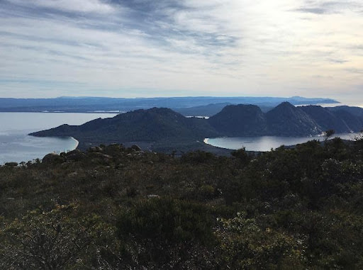
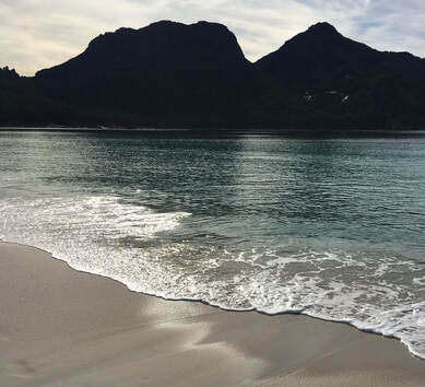
Freycinet National Park is home to dramatic pink granite peaks, secluded bays, white sandy beaches and abundant birdlife. Situated on Tasmania's beautiful east coast, the park occupies most of the Freycinet Peninsula and looks out to the Tasman Sea from the eastern side and back towards the Tasmanian coastline from the west.
|
Freycinet National Park is home to dramatic pink granite peaks, secluded bays, white sandy beaches and abundant birdlife. Situated on Tasmania's beautiful east coast, the park occupies most of the Freycinet Peninsula and looks out to the Tasman Sea from the eastern side and back towards the Tasmanian coastline from the west.
This route is inspired by Hanny's early family camping experiences to the Freycinet Peninsula. On this route you will first explore the rises and falls of the undulating coastal trail from the Wineglass Bay Track to Hazards Beach, where you will likely then find yourself meandering up a shell-strewn beach with distant views to Mt Freycinet, Mt Graham and the rest of the peninsula beyond. As you cross the isthmus towards Wineglass Bay, we suggest you pause at the vast inland lagoon, marvelling at the chorus of frogs, deliriously drunk on their frogs' wine. Finally lean into the climb back to the Wineglass Bay lookout and marvel at just how far you have come. Then whoop, whoop, whoop all the way back down the hill to the carpark. |
|
Overview
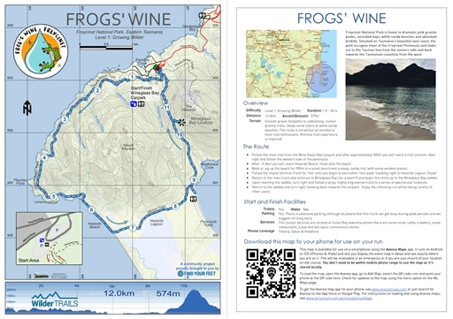
Difficulty Level 1, Growing Wilder Distance 12.0km Ascent 575m Descent 575m Terrain Smooth gravel footpaths to undulating, rockier granite trails. Steep stone stairs to white sandy beaches. The route is varied but accessible to most trail enthusiasts. Minimal trail experience is required. Approx. Duration 1.3 - 3hrs |
|
The Route
- Begin at Wineglass Bay Carpark. If you wish to make this route longer there is a newer shared use trail that begins at the official Freycinet National Park Visitor Centre. This will add approximately 7km to the route.
- Follow the main trail from the carpark and after approximately 300m you will reach a trail junction. Veer right and follow the western side of the peninsula. You will have views across to 'mainland Tasmania' from the trail.
- After 5.5km you will reach Hazards Beach. Head onto the beach.
- Walk or jog up the beach for 900m where you will find a small bench and a steep, sandy trail with some wooden planks assisting you to leave the beach and head inland.
- Follow the inland trail for around 1km until you begin to see small 'pads' or subtly worn footpaths departing from the right-hand side of the track and heading down the lagoon which you will be able to see through the trees. Stop here to enjoy the vistas of Hazards Lagoon.
- Return back to the main track and continue to Wineglass Bay... for a swim!?. NB. There is a toilet here.
- After your... swim... head back to the main track and begin the climb up to the Wineglass Bay saddle. This is a distance of approximately 1.6km with many stone or wooden stairs. Take your time and enjoy the views up to Mt Amos.
- After reaching the saddle, turn right and follow a large, highly engineered track to a series of lookouts back towards Wineglass Bay. Well done... you are nearly there!
- After visiting the viewing platform return to the saddle and turn right, heading back towards the carpark. This is a super fun, rolling downhill and whilst we hope you whoop all the way back to the carpark, we ask you to be mindful of other trail users too.
- The route ends back at the carpark from which you started your journey 12.1km ago!
- We then recommend enjoying a relaxing picnic and preferably, an overnight stay to enjoy the beauty of the rest of the Freycinet National Park and the generous hospitality of the local community!
|
Start and Finish Facilities
Toilets Yes. Water Yes. Parking Yes. There is extensive parking although be aware that this track can get busy during peak periods and we suggest arriving early. Services The closest services are located at Coles Bay township where there are some small cafes, a bakery, some restaurants, a pub and two basic convenience stores. Phone coverage Telstra, Optus & Vodafone |
|
|
Mapping & directions for this route
We have created 4 easy ways for you to choose from to safely and enjoyably navigate your way around this route. From a physical map to the more technology savvy, we have your safety at heart!
|
Here is a sample of the mapping and directions available as a PDF download or printed waterproof versions
|

FREE TO DOWNLOAD
|
Digitally interactive map for use on your smartphone (FREE)
This map is available for use on a smartphone using the Avenza Maps app. It runs on Android or iOS (iPhones & iPads) and lets you display the route map in detail and see exactly where you are on it. This will be invaluable in an emergency or if you are just unsure of your location on the course. You don’t need to be within mobile phone range to use the map as it’s stored locally. To load the map, open the Avenza app, go to Add Map, select the QR code icon and point your phone at the QR code here. To get the Avenza map app for your phone, see www.avenzamaps.com or just search for Avenza on the App Store or Google Play. For instructions on loading and using Avenza maps, see www.terrainium.com.au/UsingAvenzaMaps |
Concluded the route? Don't forget to get your completion badge or lapel pin!
I was one of those children, slumbering in the back of a sluggish, orange comby van. We loved Freycinet, especially exploring the rock pools, granite caves and vast inland lagoons. At some point not long after returning from a sandy, sun-bleached Christmas camping trip to Coles Bay, we were enjoying dinner with some family friends. My father was asked if he wanted a drink with dinner and his reply came, 'Just some frogs' wine, thanks'. - Hanny Allston
About the Freycinet National Park
Freycinet was reserved as a national park in 1916, making it the oldest national park in Tasmania, alongside Mount Field National Park. With thanks to Tasmanian Parks & Wildlife Service & Wineglass Bay for access to the following information...
Aboriginal heritage
The Freycinet National Park is located within the territory of the Oyster Bay nation which consisted of an estimated 600-700 people, and whose territory extended from the Derwent Estuary up the east coast to the Fingal Valley and westward to the Midlands. In 1816, Captain James Kelly recorded a party of Aboriginal people on Schouten Island. The historic records suggest that the Freycinet Peninsula and Schouten Island were part of the area of the toorerno-maire-mener clan within the Oyster Bay nation.
Today, significant Aboriginal sites are found along the coastlines, dunes and estuaries. This heritage includes shell middens, rock quarries, rock shelters, stone artefacts and other significant sites. The camping ground at Richardsons Beach is located adjacent to one of the most extensive shell middens known on the east coast, a highly significant cultural resource. These sites have a strong and continuing connection to the Tasmanian Aboriginal community. Please tread as gently & respectfully as you can.
Today, significant Aboriginal sites are found along the coastlines, dunes and estuaries. This heritage includes shell middens, rock quarries, rock shelters, stone artefacts and other significant sites. The camping ground at Richardsons Beach is located adjacent to one of the most extensive shell middens known on the east coast, a highly significant cultural resource. These sites have a strong and continuing connection to the Tasmanian Aboriginal community. Please tread as gently & respectfully as you can.
European Culture
Since the early years of European settlement, whaling parties, tin and coal miners, and pastoralists are among those who have lived and worked on the Freycinet Peninsula. Old mine shafts, abandoned farmers' huts and the remains of whalers' camps today form part of the rich cultural heritage of the park.
High granitic mountains whose summits are almost completely barren, form the whole eastern coast of this part of Van Diemen’s Land. They rise sheer from the base. The country which adjoins them is extremely low and cannot be seen unless viewed from only a little distance at sea. It is to this strange formation that we must doubtless attribute the errors of the navigators who had preceded us into these waters and who had mistaken these high mountains for as many separate islands.
Whaling parties, tin and coal miners and pastoralists were among those who lived and worked on the Freycinet Peninsula since the early years of European settlement. Old mine shafts, abandoned farmers’ huts and the remains of whalers’ camps today form part of the rich cultural heritage of the park.The majestic beauty of Freycinet’s granite mountains and white, sandy beaches have also long been admired by naturalists, artists and writers.
On navigating the east coast of Tasmania in 1642, Abel Tasman named Schouten Island after a member of the Council of the Dutch East India Company. The adjacent peninsula was initially thought to consist of a chain of islands, but this myth was dispelled during the visit of Nicholas Baudin, the French explorer, in 1802-03. The brothers Freycinet were senior officers on Baudin’s expedition, although it is unclear which one the peninsula was named after.
On navigating the east coast of Tasmania in 1642, Abel Tasman named Schouten Island after a member of the Council of the Dutch East India Company. The adjacent peninsula was initially thought to consist of a chain of islands, but this myth was dispelled during the visit of Nicholas Baudin, the French explorer, in 1802-03. The brothers Freycinet were senior officers on Baudin’s expedition, although it is unclear which one the peninsula was named after.
Flora & Fauna
There is an abundance of wildlife on the Freycinet Peninsula ranging from wombats, wallabies and quolls to sea eagles, black swans, whales and dolphins.
The Freycinet Peninsula is one of the State's most scenic coastal areas. The waters off the Freycinet Peninsula are regularly visited by whales, particularly southern right whales, during the winter months. Mammals such as Bennett's wallabies, pademelons, and echidnas are commonly seen on land, while seals may be spotted resting on rocks.
Freycinet is also a great place to see birds, ranging from small nectar-feeding birds to spectacularly large birds. From Wineglass Bay and Cape Tourville lookouts you may be lucky enough to see white-bellied sea-eagles gliding overhead or Australasian gannets diving for food in the ocean. Wildflowers are also common at most times of the year.
Freycinet is also a great place to see birds, ranging from small nectar-feeding birds to spectacularly large birds. From Wineglass Bay and Cape Tourville lookouts you may be lucky enough to see white-bellied sea-eagles gliding overhead or Australasian gannets diving for food in the ocean. Wildflowers are also common at most times of the year.
Geodiversity
The Freycinet Peninsula has formed over 400 million years and is effectively two eroded blocks of granite – the Hazards and the peninsula of Mount Graham and Mount Freycinet – connected by the sand isthmus that forms Wineglass Bay. The reason why the beaches are so white at Freycinet is thanks to the high levels of white quartz in the granite. This is a very hard type of rock which takes longest to erode, thereby washing up on the beaches to create long stretches of perfect sand. In fact, the sand is so pure that silicon mining at the Friendly Beaches in the Park's north was proposed. The granite also contains pink feldspar which causes the hazards to glow a reddish pink colour at sunrise and sunset.
Help Freycinet & its surrounds!
There are some active volunteer groups who help to preserve & protect the Freycinet Peninsula. We strongly encourage you to get involved!